 Note:
The expiration time in the watch graphic is amended if the watch is
replaced, cancelled or extended.
Note:
Note:
The expiration time in the watch graphic is amended if the watch is
replaced, cancelled or extended.
Note: Click for
Watch Status Reports.
SEL7
URGENT - IMMEDIATE BROADCAST REQUESTED
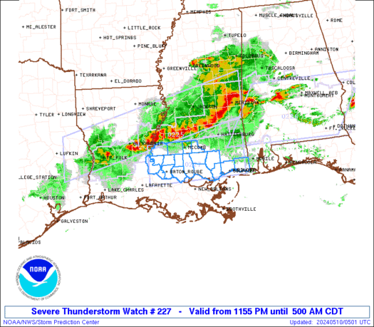
Severe Thunderstorm Watch Number 227
NWS Storm Prediction Center Norman OK
1155 PM CDT Thu May 9 2024
The NWS Storm Prediction Center has issued a
* Severe Thunderstorm Watch for portions of
Southeast Louisiana
Southern Mississippi
* Effective this Thursday night and Friday morning from 1155 PM
until 500 AM CDT.
* Primary threats include...
Widespread damaging winds and isolated significant gusts to 80
mph likely
Scattered large hail and isolated very large hail events to 2
inches in diameter possible
A tornado or two possible
SUMMARY...Intense thunderstorms over central Louisiana will track
east-southeastward overnight across the watch area. Damaging winds
will be possible with these storms.
The severe thunderstorm watch area is approximately along and 40
statute miles north and south of a line from 80 miles west southwest
of Mc Comb MS to 45 miles northeast of Gulfport MS. For a complete
depiction of the watch see the associated watch outline update
(WOUS64 KWNS WOU7).
PRECAUTIONARY/PREPAREDNESS ACTIONS...
REMEMBER...A Severe Thunderstorm Watch means conditions are
favorable for severe thunderstorms in and close to the watch area.
Persons in these areas should be on the lookout for threatening
weather conditions and listen for later statements and possible
warnings. Severe thunderstorms can and occasionally do produce
tornadoes.
&&
OTHER WATCH INFORMATION...CONTINUE...WW 224...WW 225...WW 226...
AVIATION...A few severe thunderstorms with hail surface and aloft to
2 inches. Extreme turbulence and surface wind gusts to 70 knots. A
few cumulonimbi with maximum tops to 500. Mean storm motion vector
28035.
...Hart
 Note:
The Aviation Watch (SAW) product is an approximation to the watch area.
The actual watch is depicted by the shaded areas.
Note:
The Aviation Watch (SAW) product is an approximation to the watch area.
The actual watch is depicted by the shaded areas.
   SAW7
   WW 227 SEVERE TSTM LA MS 100455Z - 101000Z
   AXIS..40 STATUTE MILES NORTH AND SOUTH OF LINE..
   80WSW MCB/MC COMB MS/ - 45NE GPT/GULFPORT MS/
   ..AVIATION COORDS.. 35NM N/S /26NW BTR - 12NW SJI/
   HAIL SURFACE AND ALOFT..2 INCHES. WIND GUSTS..70 KNOTS.
   MAX TOPS TO 500. MEAN STORM MOTION VECTOR 28035.

   LAT...LON 31319171 31448853 30288853 30159171

   THIS IS AN APPROXIMATION TO THE WATCH AREA.  FOR A
   COMPLETE DEPICTION OF THE WATCH SEE WOUS64 KWNS
   FOR WOU7.
Watch 227 Status Report Messages:
STATUS REPORT #3 ON WW 227

VALID 100840Z - 100940Z

SEVERE WEATHER THREAT CONTINUES RIGHT OF A LINE FROM 20 SW GPT TO
40 NNE GPT TO 20 NNW MOB.

..BROYLES..05/10/24

ATTN...WFO...LIX...

&&

STATUS REPORT FOR WS 227

SEVERE WEATHER THREAT CONTINUES FOR THE FOLLOWING AREAS

MSC047-059-100940-

MS
.    MISSISSIPPI COUNTIES INCLUDED ARE

HARRISON	     JACKSON
$$


THE WATCH STATUS MESSAGE IS FOR GUIDANCE PURPOSES ONLY.  PLEASE
REFER TO WATCH COUNTY NOTIFICATION STATEMENTS FOR OFFICIAL
INFORMATION ON COUNTIES...INDEPENDENT CITIES AND MARINE ZONES
CLEARED FROM SEVERE THUNDERSTORM AND TORNADO WATCHES.
$$

STATUS REPORT #2 ON WW 227

VALID 100750Z - 100840Z

SEVERE WEATHER THREAT CONTINUES RIGHT OF A LINE FROM 15 WSW ASD
TO 25 N ASD TO 20 SSW PIB TO 45 NNW MOB.

..BROYLES..05/10/24

ATTN...WFO...LIX...

&&

STATUS REPORT FOR WS 227

SEVERE WEATHER THREAT CONTINUES FOR THE FOLLOWING AREAS

LAC103-100840-

LA
.    LOUISIANA PARISHES INCLUDED ARE

ST. TAMMANY
$$


MSC045-047-059-109-100840-

MS
.    MISSISSIPPI COUNTIES INCLUDED ARE

HANCOCK 	     HARRISON		 JACKSON
PEARL RIVER
$$


THE WATCH STATUS MESSAGE IS FOR GUIDANCE PURPOSES ONLY.  PLEASE
REFER TO WATCH COUNTY NOTIFICATION STATEMENTS FOR OFFICIAL
INFORMATION ON COUNTIES...INDEPENDENT CITIES AND MARINE ZONES
CLEARED FROM SEVERE THUNDERSTORM AND TORNADO WATCHES.
$$

STATUS REPORT #1 ON WW 227

VALID 100625Z - 100740Z

THE SEVERE WEATHER THREAT CONTINUES ACROSS THE ENTIRE WATCH AREA.

..BROYLES..05/10/24

ATTN...WFO...LIX...

&&

STATUS REPORT FOR WS 227

SEVERE WEATHER THREAT CONTINUES FOR THE FOLLOWING AREAS

LAC033-037-063-077-091-103-105-117-121-125-100740-

LA
.    LOUISIANA PARISHES INCLUDED ARE

EAST BATON ROUGE     EAST FELICIANA	 LIVINGSTON
POINTE COUPEE	     ST. HELENA 	 ST. TAMMANY
TANGIPAHOA	     WASHINGTON 	 WEST BATON ROUGE
WEST FELICIANA
$$


MSC005-045-047-059-109-113-147-157-100740-

MS
.    MISSISSIPPI COUNTIES INCLUDED ARE

AMITE		     HANCOCK		 HARRISON
JACKSON 	     PEARL RIVER	 PIKE
WALTHALL	     WILKINSON
$$


THE WATCH STATUS MESSAGE IS FOR GUIDANCE PURPOSES ONLY.  PLEASE
REFER TO WATCH COUNTY NOTIFICATION STATEMENTS FOR OFFICIAL
INFORMATION ON COUNTIES...INDEPENDENT CITIES AND MARINE ZONES
CLEARED FROM SEVERE THUNDERSTORM AND TORNADO WATCHES.
$$
Note:
Click for Complete Product Text.
Tornadoes
Probability of 2 or more tornadoes
|
Low (20%)
|
Probability of 1 or more strong (EF2-EF5) tornadoes
|
Low (10%)
|
Wind
Probability of 10 or more severe wind events
|
High (80%)
|
Probability of 1 or more wind events > 65 knots
|
High (70%)
|
Hail
Probability of 10 or more severe hail events
|
Mod (40%)
|
Probability of 1 or more hailstones > 2 inches
|
Mod (30%)
|
Combined Severe Hail/Wind
Probability of 6 or more combined severe hail/wind events
|
High (>95%)
|
For each watch, probabilities for particular events inside the watch
(listed above in each table) are determined by the issuing forecaster.
The "Low" category contains probability values ranging from less than 2%
to 20% (EF2-EF5 tornadoes), less than 5% to 20% (all other probabilities),
"Moderate" from 30% to 60%, and "High" from 70% to greater than 95%.
High values are bolded and lighter in color to provide awareness of
an increased threat for a particular event.


 @NWSSPC


