 Note:
The expiration time in the watch graphic is amended if the watch is
replaced, cancelled or extended.
Note:
Note:
The expiration time in the watch graphic is amended if the watch is
replaced, cancelled or extended.
Note: Click for
Watch Status Reports.
SEL2
URGENT - IMMEDIATE BROADCAST REQUESTED
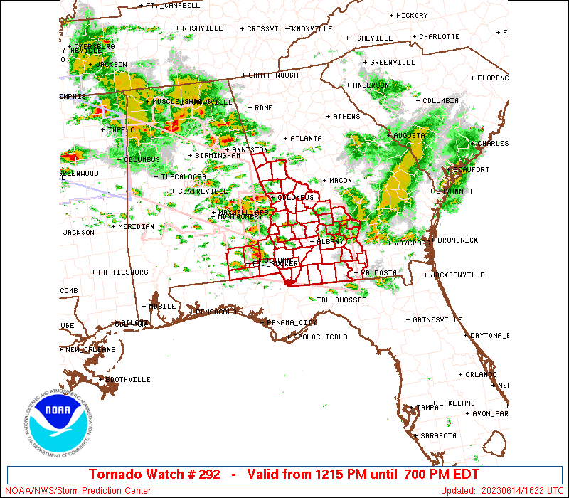
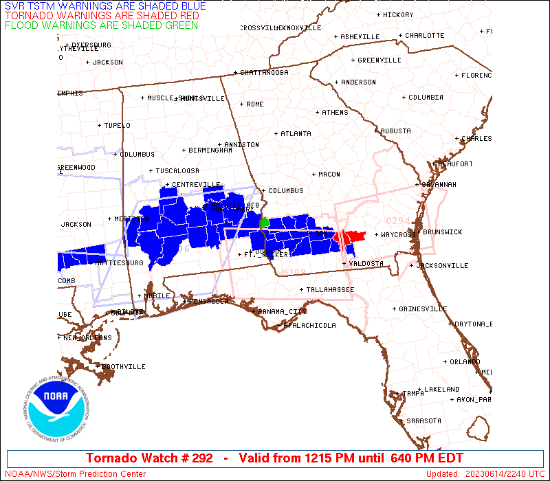
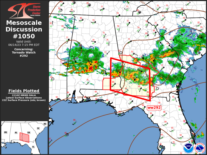
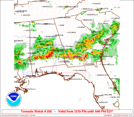
Tornado Watch Number 292
NWS Storm Prediction Center Norman OK
1215 PM EDT Wed Jun 14 2023
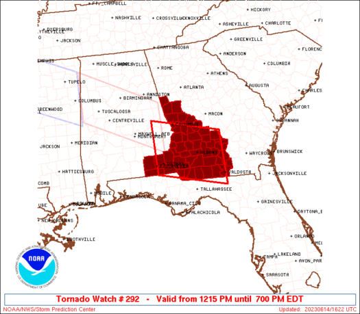
The NWS Storm Prediction Center has issued a
* Tornado Watch for portions of
Southeast Alabama
West-central and Southwest Georgia
* Effective this Wednesday afternoon and evening from 1215 PM
until 700 PM EDT.
* Primary threats include...
A few tornadoes likely with a couple intense tornadoes possible
Scattered damaging winds and isolated significant gusts to 80
mph likely
Scattered large hail likely with isolated very large hail events
to 2.5 inches in diameter possible
SUMMARY...Thunderstorms should strengthen through the afternoon,
while posing a threat for very large hail, severe/damaging winds,
and a few tornadoes.
The tornado watch area is approximately along and 60 statute miles
north and south of a line from 40 miles north northwest of Dothan AL
to 35 miles east northeast of Moultrie GA. For a complete depiction
of the watch see the associated watch outline update (WOUS64 KWNS
WOU2).
PRECAUTIONARY/PREPAREDNESS ACTIONS...
REMEMBER...A Tornado Watch means conditions are favorable for
tornadoes and severe thunderstorms in and close to the watch
area. Persons in these areas should be on the lookout for
threatening weather conditions and listen for later statements
and possible warnings.
&&
OTHER WATCH INFORMATION...CONTINUE...WW 289...WW 290...WW 291...
AVIATION...Tornadoes and a few severe thunderstorms with hail
surface and aloft to 2.5 inches. Extreme turbulence and surface wind
gusts to 70 knots. A few cumulonimbi with maximum tops to 600. Mean
storm motion vector 28035.
...Gleason/Thompson

   SEL2

   URGENT - IMMEDIATE BROADCAST REQUESTED
   Tornado Watch Number 292
   NWS Storm Prediction Center Norman OK
   1215 PM EDT Wed Jun 14 2023

   The NWS Storm Prediction Center has issued a

   * Tornado Watch for portions of
     Southeast Alabama
     West-central and Southwest Georgia

   * Effective this Wednesday afternoon and evening from 1215 PM
     until 700 PM EDT.

   * Primary threats include...
     A few tornadoes likely with a couple intense tornadoes possible
     Scattered damaging winds and isolated significant gusts to 80
       mph likely
     Scattered large hail likely with isolated very large hail events
       to 2.5 inches in diameter possible

   SUMMARY...Thunderstorms should strengthen through the afternoon,
   while posing a threat for very large hail, severe/damaging winds,
   and a few tornadoes.

   The tornado watch area is approximately along and 60 statute miles
   north and south of a line from 40 miles north northwest of Dothan AL
   to 35 miles east northeast of Moultrie GA. For a complete depiction
   of the watch see the associated watch outline update (WOUS64 KWNS
   WOU2).

   PRECAUTIONARY/PREPAREDNESS ACTIONS...

   REMEMBER...A Tornado Watch means conditions are favorable for
   tornadoes and severe thunderstorms in and close to the watch
   area. Persons in these areas should be on the lookout for
   threatening weather conditions and listen for later statements
   and possible warnings.

   &&

   OTHER WATCH INFORMATION...CONTINUE...WW 289...WW 290...WW 291...

   AVIATION...Tornadoes and a few severe thunderstorms with hail
   surface and aloft to 2.5 inches. Extreme turbulence and surface wind
   gusts to 70 knots. A few cumulonimbi with maximum tops to 600. Mean
   storm motion vector 28035.

   ...Gleason/Thompson
 Note:
The Aviation Watch (SAW) product is an approximation to the watch area.
The actual watch is depicted by the shaded areas.
Note:
The Aviation Watch (SAW) product is an approximation to the watch area.
The actual watch is depicted by the shaded areas.
   SAW2
   WW 292 TORNADO AL GA 141615Z - 142300Z
   AXIS..60 STATUTE MILES NORTH AND SOUTH OF LINE..
   40NNW DHN/DOTHAN AL/ - 35ENE MGR/MOULTRIE GA/
   ..AVIATION COORDS.. 50NM N/S /38SE MGM - 41WSW AMG/
   HAIL SURFACE AND ALOFT..2.5 INCHES. WIND GUSTS..70 KNOTS.
   MAX TOPS TO 600. MEAN STORM MOTION VECTOR 28035.

   LAT...LON 32728571 32148325 30408325 30998571

   THIS IS AN APPROXIMATION TO THE WATCH AREA.  FOR A
   COMPLETE DEPICTION OF THE WATCH SEE WOUS64 KWNS
   FOR WOU2.
Watch 292 Status Report Messages:
STATUS REPORT #4 ON WW 292

VALID 142055Z - 142140Z

THE SEVERE WEATHER THREAT CONTINUES ACROSS THE ENTIRE WATCH AREA.

..LYONS..06/14/23

ATTN...WFO...TAE...FFC...

&&

STATUS REPORT FOR WT 292

SEVERE WEATHER THREAT CONTINUES FOR THE FOLLOWING AREAS

ALC031-045-061-067-069-142140-

AL
.    ALABAMA COUNTIES INCLUDED ARE

COFFEE		     DALE		 GENEVA
HENRY		     HOUSTON
$$


GAC007-017-019-027-037-053-061-071-075-081-087-093-095-099-131-
145-149-155-173-177-185-193-197-199-201-205-215-239-243-249-253-
259-261-263-269-273-275-277-285-287-307-315-321-142140-

GA
.    GEORGIA COUNTIES INCLUDED ARE

BAKER		     BEN HILL		 BERRIEN
BROOKS		     CALHOUN		 CHATTAHOOCHEE
CLAY		     COLQUITT		 COOK
CRISP		     DECATUR		 DOOLY
DOUGHERTY	     EARLY		 GRADY
HARRIS		     HEARD		 IRWIN
LANIER		     LEE		 LOWNDES
MACON		     MARION		 MERIWETHER
MILLER		     MITCHELL		 MUSCOGEE
QUITMAN 	     RANDOLPH		 SCHLEY
SEMINOLE	     STEWART		 SUMTER
TALBOT		     TAYLOR		 TERRELL
THOMAS		     TIFT		 TROUP
TURNER		     WEBSTER		 WILCOX
WORTH
$$


THE WATCH STATUS MESSAGE IS FOR GUIDANCE PURPOSES ONLY.  PLEASE
REFER TO WATCH COUNTY NOTIFICATION STATEMENTS FOR OFFICIAL
INFORMATION ON COUNTIES...INDEPENDENT CITIES AND MARINE ZONES
CLEARED FROM SEVERE THUNDERSTORM AND TORNADO WATCHES.
$$

STATUS REPORT #3 ON WW 292

VALID 141950Z - 142040Z

SEVERE WEATHER THREAT CONTINUES RIGHT OF A LINE FROM MAI TO 10 S
TOI.

..LYONS..06/14/23

ATTN...WFO...TAE...FFC...

&&

STATUS REPORT FOR WT 292

SEVERE WEATHER THREAT CONTINUES FOR THE FOLLOWING AREAS

ALC067-069-142040-

AL
.    ALABAMA COUNTIES INCLUDED ARE

HENRY		     HOUSTON
$$


GAC007-017-019-027-037-053-061-071-075-081-087-093-095-099-131-
145-149-155-173-177-185-193-197-199-201-205-215-239-243-249-253-
259-261-263-269-273-275-277-285-287-307-315-321-142040-

GA
.    GEORGIA COUNTIES INCLUDED ARE

BAKER		     BEN HILL		 BERRIEN
BROOKS		     CALHOUN		 CHATTAHOOCHEE
CLAY		     COLQUITT		 COOK
CRISP		     DECATUR		 DOOLY
DOUGHERTY	     EARLY		 GRADY
HARRIS		     HEARD		 IRWIN
LANIER		     LEE		 LOWNDES
MACON		     MARION		 MERIWETHER
MILLER		     MITCHELL		 MUSCOGEE
QUITMAN 	     RANDOLPH		 SCHLEY
SEMINOLE	     STEWART		 SUMTER
TALBOT		     TAYLOR		 TERRELL
THOMAS		     TIFT		 TROUP
TURNER		     WEBSTER		 WILCOX
WORTH
$$


THE WATCH STATUS MESSAGE IS FOR GUIDANCE PURPOSES ONLY.  PLEASE
REFER TO WATCH COUNTY NOTIFICATION STATEMENTS FOR OFFICIAL
INFORMATION ON COUNTIES...INDEPENDENT CITIES AND MARINE ZONES
CLEARED FROM SEVERE THUNDERSTORM AND TORNADO WATCHES.
$$

STATUS REPORT #2 ON WW 292

VALID 141855Z - 141940Z

THE SEVERE WEATHER THREAT CONTINUES ACROSS THE ENTIRE WATCH AREA.

..LYONS..06/14/23

ATTN...WFO...TAE...FFC...

&&

STATUS REPORT FOR WT 292

SEVERE WEATHER THREAT CONTINUES FOR THE FOLLOWING AREAS

ALC031-045-061-067-069-141940-

AL
.    ALABAMA COUNTIES INCLUDED ARE

COFFEE		     DALE		 GENEVA
HENRY		     HOUSTON
$$


GAC007-017-019-027-037-053-061-071-075-081-087-093-095-099-131-
145-149-155-173-177-185-193-197-199-201-205-215-239-243-249-253-
259-261-263-269-273-275-277-285-287-307-315-321-141940-

GA
.    GEORGIA COUNTIES INCLUDED ARE

BAKER		     BEN HILL		 BERRIEN
BROOKS		     CALHOUN		 CHATTAHOOCHEE
CLAY		     COLQUITT		 COOK
CRISP		     DECATUR		 DOOLY
DOUGHERTY	     EARLY		 GRADY
HARRIS		     HEARD		 IRWIN
LANIER		     LEE		 LOWNDES
MACON		     MARION		 MERIWETHER
MILLER		     MITCHELL		 MUSCOGEE
QUITMAN 	     RANDOLPH		 SCHLEY
SEMINOLE	     STEWART		 SUMTER
TALBOT		     TAYLOR		 TERRELL
THOMAS		     TIFT		 TROUP
TURNER		     WEBSTER		 WILCOX
WORTH
$$


THE WATCH STATUS MESSAGE IS FOR GUIDANCE PURPOSES ONLY.  PLEASE
REFER TO WATCH COUNTY NOTIFICATION STATEMENTS FOR OFFICIAL
INFORMATION ON COUNTIES...INDEPENDENT CITIES AND MARINE ZONES
CLEARED FROM SEVERE THUNDERSTORM AND TORNADO WATCHES.
$$

STATUS REPORT #1 ON WW 292

VALID 141745Z - 141840Z

THE SEVERE WEATHER THREAT CONTINUES ACROSS THE ENTIRE WATCH AREA.

..LYONS..06/14/23

ATTN...WFO...TAE...FFC...

&&

STATUS REPORT FOR WT 292

SEVERE WEATHER THREAT CONTINUES FOR THE FOLLOWING AREAS

ALC031-045-061-067-069-141840-

AL
.    ALABAMA COUNTIES INCLUDED ARE

COFFEE		     DALE		 GENEVA
HENRY		     HOUSTON
$$


GAC007-017-019-027-037-053-061-071-075-081-087-093-095-099-131-
145-149-155-173-177-185-193-197-199-201-205-215-239-243-249-253-
259-261-263-269-273-275-277-285-287-307-315-321-141840-

GA
.    GEORGIA COUNTIES INCLUDED ARE

BAKER		     BEN HILL		 BERRIEN
BROOKS		     CALHOUN		 CHATTAHOOCHEE
CLAY		     COLQUITT		 COOK
CRISP		     DECATUR		 DOOLY
DOUGHERTY	     EARLY		 GRADY
HARRIS		     HEARD		 IRWIN
LANIER		     LEE		 LOWNDES
MACON		     MARION		 MERIWETHER
MILLER		     MITCHELL		 MUSCOGEE
QUITMAN 	     RANDOLPH		 SCHLEY
SEMINOLE	     STEWART		 SUMTER
TALBOT		     TAYLOR		 TERRELL
THOMAS		     TIFT		 TROUP
TURNER		     WEBSTER		 WILCOX
WORTH
$$


THE WATCH STATUS MESSAGE IS FOR GUIDANCE PURPOSES ONLY.  PLEASE
REFER TO WATCH COUNTY NOTIFICATION STATEMENTS FOR OFFICIAL
INFORMATION ON COUNTIES...INDEPENDENT CITIES AND MARINE ZONES
CLEARED FROM SEVERE THUNDERSTORM AND TORNADO WATCHES.
$$
Note:
Click for Complete Product Text.
Tornadoes
Probability of 2 or more tornadoes
|
Mod (60%)
|
Probability of 1 or more strong (EF2-EF5) tornadoes
|
Mod (30%)
|
Wind
Probability of 10 or more severe wind events
|
High (70%)
|
Probability of 1 or more wind events > 65 knots
|
Mod (60%)
|
Hail
Probability of 10 or more severe hail events
|
Mod (60%)
|
Probability of 1 or more hailstones > 2 inches
|
Mod (40%)
|
Combined Severe Hail/Wind
Probability of 6 or more combined severe hail/wind events
|
High (>95%)
|
For each watch, probabilities for particular events inside the watch
(listed above in each table) are determined by the issuing forecaster.
The "Low" category contains probability values ranging from less than 2%
to 20% (EF2-EF5 tornadoes), less than 5% to 20% (all other probabilities),
"Moderate" from 30% to 60%, and "High" from 70% to greater than 95%.
High values are bolded and lighter in color to provide awareness of
an increased threat for a particular event.


 @NWSSPC