Note:
The expiration time in the watch graphic is amended if the watch is
replaced, cancelled or extended.
Note:
Note:
The expiration time in the watch graphic is amended if the watch is
replaced, cancelled or extended.
Note: Click for
Watch Status Reports.
SEL8
URGENT - IMMEDIATE BROADCAST REQUESTED
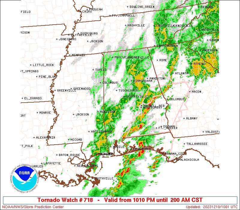
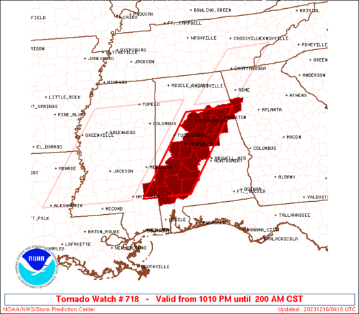
Tornado Watch Number 718
NWS Storm Prediction Center Norman OK
1010 PM CST Sat Dec 9 2023
The NWS Storm Prediction Center has issued a
* Tornado Watch for portions of
central and southern Alabama
parts of northwestern Georgia
a portion of southeastern Mississippi
* Effective this Saturday night and Sunday morning from 1010 PM
until 200 AM CST.
* Primary threats include...
A couple tornadoes possible
Isolated damaging wind gusts to 65 mph possible
SUMMARY...A band of strong/locally severe thunderstorms will
continue advancing eastward across the Mississippi/Alabama area into
the overnight period. Locally strong/damaging wind gusts will be
possible, along with a couple of brief tornadoes.
The tornado watch area is approximately along and 50 statute miles
east and west of a line from 30 miles northwest of Anniston AL to 95
miles southwest of Selma AL. For a complete depiction of the watch
see the associated watch outline update (WOUS64 KWNS WOU8).
PRECAUTIONARY/PREPAREDNESS ACTIONS...
REMEMBER...A Tornado Watch means conditions are favorable for
tornadoes and severe thunderstorms in and close to the watch
area. Persons in these areas should be on the lookout for
threatening weather conditions and listen for later statements
and possible warnings.
&&
OTHER WATCH INFORMATION...CONTINUE...WW 715...WW 716...WW 717...
AVIATION...Tornadoes and a few severe thunderstorms with hail
surface and aloft to 1 inch. Extreme turbulence and surface wind
gusts to 55 knots. A few cumulonimbi with maximum tops to 450. Mean
storm motion vector 24035.
...Goss

   SEL8

   URGENT - IMMEDIATE BROADCAST REQUESTED
   Tornado Watch Number 718
   NWS Storm Prediction Center Norman OK
   1010 PM CST Sat Dec 9 2023

   The NWS Storm Prediction Center has issued a

   * Tornado Watch for portions of
     central and southern Alabama
     parts of northwestern Georgia
     a portion of southeastern Mississippi

   * Effective this Saturday night and Sunday morning from 1010 PM
     until 200 AM CST.

   * Primary threats include...
     A couple tornadoes possible
     Isolated damaging wind gusts to 65 mph possible

   SUMMARY...A band of strong/locally severe thunderstorms will
   continue advancing eastward across the Mississippi/Alabama area into
   the overnight period.  Locally strong/damaging wind gusts will be
   possible, along with a couple of brief tornadoes.

   The tornado watch area is approximately along and 50 statute miles
   east and west of a line from 30 miles northwest of Anniston AL to 95
   miles southwest of Selma AL. For a complete depiction of the watch
   see the associated watch outline update (WOUS64 KWNS WOU8).

   PRECAUTIONARY/PREPAREDNESS ACTIONS...

   REMEMBER...A Tornado Watch means conditions are favorable for
   tornadoes and severe thunderstorms in and close to the watch
   area. Persons in these areas should be on the lookout for
   threatening weather conditions and listen for later statements
   and possible warnings.

   &&

   OTHER WATCH INFORMATION...CONTINUE...WW 715...WW 716...WW 717...

   AVIATION...Tornadoes and a few severe thunderstorms with hail
   surface and aloft to 1 inch. Extreme turbulence and surface wind
   gusts to 55 knots. A few cumulonimbi with maximum tops to 450. Mean
   storm motion vector 24035.

   ...Goss
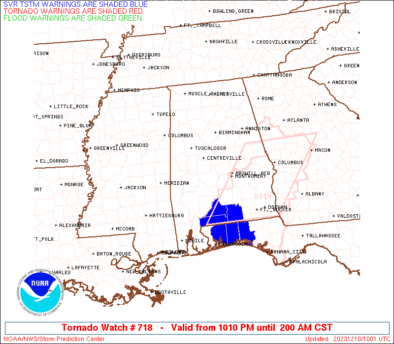
 Note:
The Aviation Watch (SAW) product is an approximation to the watch area.
The actual watch is depicted by the shaded areas.
Note:
The Aviation Watch (SAW) product is an approximation to the watch area.
The actual watch is depicted by the shaded areas.
   SAW8
   WW 718 TORNADO AL GA MS 100410Z - 100800Z
   AXIS..50 STATUTE MILES EAST AND WEST OF LINE..
   30NW ANB/ANNISTON AL/ - 95SW SEM/SELMA AL/
   ..AVIATION COORDS.. 45NM E/W /36ENE VUZ - 41NNE SJI/
   HAIL SURFACE AND ALOFT..1 INCH. WIND GUSTS..55 KNOTS.
   MAX TOPS TO 450. MEAN STORM MOTION VECTOR 24035.

   LAT...LON 33888535 31378727 31378897 33888709

   THIS IS AN APPROXIMATION TO THE WATCH AREA.  FOR A
   COMPLETE DEPICTION OF THE WATCH SEE WOUS64 KWNS
   FOR WOU8.
Watch 718 Status Report Messages:
STATUS REPORT #2 ON WW 718
VALID 100745Z - 100840Z
SEVERE WEATHER THREAT CONTINUES RIGHT OF A LINE FROM 25 E MEI TO
5 WNW SEM TO 30 N MGM TO 20 SW ANB TO 20 NE GAD.
..GLEASON..12/10/23
ATTN...WFO...BMX...MOB...FFC...
&&
STATUS REPORT FOR WT 718
SEVERE WEATHER THREAT CONTINUES FOR THE FOLLOWING AREAS
ALC001-015-023-025-027-029-037-047-091-099-121-129-131-100840-
AL
. ALABAMA COUNTIES INCLUDED ARE
AUTAUGA CALHOUN CHOCTAW
CLARKE CLAY CLEBURNE
COOSA DALLAS MARENGO
MONROE TALLADEGA WASHINGTON
WILCOX
$$
GAC143-233-100840-
GA
. GEORGIA COUNTIES INCLUDED ARE
HARALSON POLK
$$
MSC153-100840-
MS
. MISSISSIPPI COUNTIES INCLUDED ARE
WAYNE
$$
THE WATCH STATUS MESSAGE IS FOR GUIDANCE PURPOSES ONLY. PLEASE
REFER TO WATCH COUNTY NOTIFICATION STATEMENTS FOR OFFICIAL
INFORMATION ON COUNTIES...INDEPENDENT CITIES AND MARINE ZONES
CLEARED FROM SEVERE THUNDERSTORM AND TORNADO WATCHES.
$$
STATUS REPORT #1 ON WW 718
VALID 100645Z - 100740Z
SEVERE WEATHER THREAT CONTINUES RIGHT OF A LINE FROM 25 E MEI TO
35 W SEM TO 15 ESE BHM TO 25 W GAD.
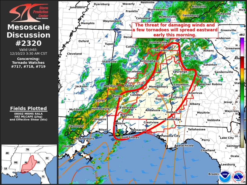
FOR ADDITIONAL INFORMATION SEE MESOSCALE DISCUSSION 2319
..GLEASON..12/10/23
ATTN...WFO...BMX...MOB...FFC...
&&
STATUS REPORT FOR WT 718
SEVERE WEATHER THREAT CONTINUES FOR THE FOLLOWING AREAS
ALC001-007-015-021-023-025-027-029-037-047-091-099-105-115-117-
121-129-131-100740-
AL
. ALABAMA COUNTIES INCLUDED ARE
AUTAUGA BIBB CALHOUN
CHILTON CHOCTAW CLARKE
CLAY CLEBURNE COOSA
DALLAS MARENGO MONROE
PERRY ST. CLAIR SHELBY
TALLADEGA WASHINGTON WILCOX
$$
GAC143-233-100740-
GA
. GEORGIA COUNTIES INCLUDED ARE
HARALSON POLK
$$
MSC153-100740-
MS
. MISSISSIPPI COUNTIES INCLUDED ARE
WAYNE
$$
THE WATCH STATUS MESSAGE IS FOR GUIDANCE PURPOSES ONLY. PLEASE
REFER TO WATCH COUNTY NOTIFICATION STATEMENTS FOR OFFICIAL
INFORMATION ON COUNTIES...INDEPENDENT CITIES AND MARINE ZONES
CLEARED FROM SEVERE THUNDERSTORM AND TORNADO WATCHES.
$$
Note:
Click for Complete Product Text.
Tornadoes
Probability of 2 or more tornadoes
|
Mod (40%)
|
Probability of 1 or more strong (EF2-EF5) tornadoes
|
Low (10%)
|
Wind
Probability of 10 or more severe wind events
|
Low (20%)
|
Probability of 1 or more wind events > 65 knots
|
Low (10%)
|
Hail
Probability of 10 or more severe hail events
|
Low (<5%)
|
Probability of 1 or more hailstones > 2 inches
|
Low (<5%)
|
Combined Severe Hail/Wind
Probability of 6 or more combined severe hail/wind events
|
Mod (40%)
|
For each watch, probabilities for particular events inside the watch
(listed above in each table) are determined by the issuing forecaster.
The "Low" category contains probability values ranging from less than 2%
to 20% (EF2-EF5 tornadoes), less than 5% to 20% (all other probabilities),
"Moderate" from 30% to 60%, and "High" from 70% to greater than 95%.
High values are bolded and lighter in color to provide awareness of
an increased threat for a particular event.


 @NWSSPC