 Note:
The expiration time in the watch graphic is amended if the watch is
replaced, cancelled or extended.
Note:
Note:
The expiration time in the watch graphic is amended if the watch is
replaced, cancelled or extended.
Note: Click for
Watch Status Reports.
SEL4
URGENT - IMMEDIATE BROADCAST REQUESTED
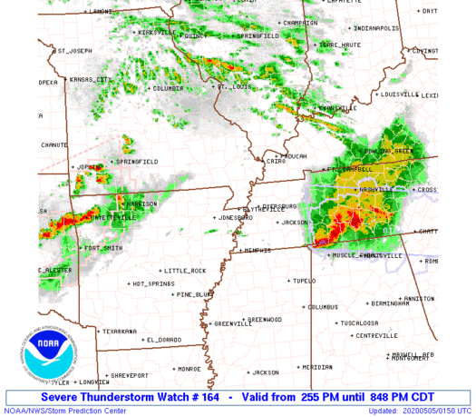
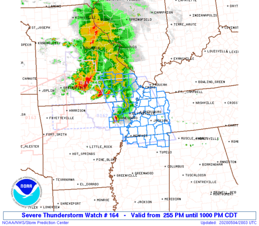
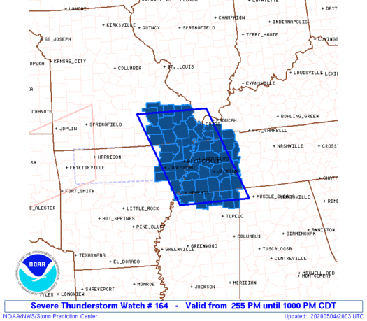
Severe Thunderstorm Watch Number 164
NWS Storm Prediction Center Norman OK
255 PM CDT Mon May 4 2020
The NWS Storm Prediction Center has issued a
* Severe Thunderstorm Watch for portions of
Northeast Arkansas
Western Kentucky
Southeast Missouri
Northern Mississippi
Western Tennessee
* Effective this Monday afternoon and evening from 255 PM until
1000 PM CDT.
* Primary threats include...
Scattered large hail likely with isolated very large hail events
to 2 inches in diameter possible
Scattered damaging wind gusts to 70 mph likely
A tornado or two possible
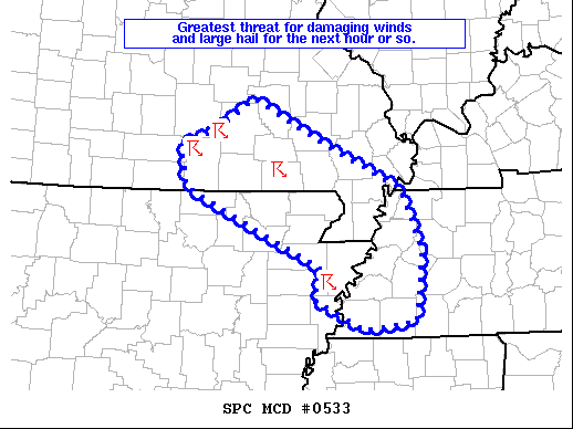
SUMMARY...Thunderstorms over Missouri and Arkansas will track
southeastward across the watch area this afternoon and evening,
posing a risk of large hail and damaging wind gusts. There is also
a low risk of a tornado or two over west TN along the warm front.
The severe thunderstorm watch area is approximately along and 70
statute miles east and west of a line from 40 miles west northwest
of Cape Girardeau MO to 60 miles east southeast of Memphis TN. For a
complete depiction of the watch see the associated watch outline
update (WOUS64 KWNS WOU4).
PRECAUTIONARY/PREPAREDNESS ACTIONS...
REMEMBER...A Severe Thunderstorm Watch means conditions are
favorable for severe thunderstorms in and close to the watch area.
Persons in these areas should be on the lookout for threatening
weather conditions and listen for later statements and possible
warnings. Severe thunderstorms can and occasionally do produce
tornadoes.
&&
OTHER WATCH INFORMATION...CONTINUE...WW 161...WW 162...WW 163...
AVIATION...A few severe thunderstorms with hail surface and aloft to
2 inches. Extreme turbulence and surface wind gusts to 60 knots. A
few cumulonimbi with maximum tops to 500. Mean storm motion vector
28035.
...Hart
   SEL4

   URGENT - IMMEDIATE BROADCAST REQUESTED
   Severe Thunderstorm Watch Number 164
   NWS Storm Prediction Center Norman OK
   255 PM CDT Mon May 4 2020

   The NWS Storm Prediction Center has issued a

   * Severe Thunderstorm Watch for portions of
     Northeast Arkansas
     Western Kentucky
     Southeast Missouri
     Northern Mississippi
     Western Tennessee

   * Effective this Monday afternoon and evening from 255 PM until
     1000 PM CDT.

   * Primary threats include...
     Scattered large hail likely with isolated very large hail events
       to 2 inches in diameter possible
     Scattered damaging wind gusts to 70 mph likely
     A tornado or two possible

   SUMMARY...Thunderstorms over Missouri and Arkansas will track
   southeastward across the watch area this afternoon and evening,
   posing a risk of large hail and damaging wind gusts.  There is also
   a low risk of a tornado or two over west TN along the warm front.

   The severe thunderstorm watch area is approximately along and 70
   statute miles east and west of a line from 40 miles west northwest
   of Cape Girardeau MO to 60 miles east southeast of Memphis TN. For a
   complete depiction of the watch see the associated watch outline
   update (WOUS64 KWNS WOU4).

   PRECAUTIONARY/PREPAREDNESS ACTIONS...

   REMEMBER...A Severe Thunderstorm Watch means conditions are
   favorable for severe thunderstorms in and close to the watch area.
   Persons in these areas should be on the lookout for threatening
   weather conditions and listen for later statements and possible
   warnings. Severe thunderstorms can and occasionally do produce
   tornadoes.

   &&

   OTHER WATCH INFORMATION...CONTINUE...WW 161...WW 162...WW 163...

   AVIATION...A few severe thunderstorms with hail surface and aloft to
   2 inches. Extreme turbulence and surface wind gusts to 60 knots. A
   few cumulonimbi with maximum tops to 500. Mean storm motion vector
   28035.

   ...Hart
 Note:
The Aviation Watch (SAW) product is an approximation to the watch area.
The actual watch is depicted by the shaded areas.
Note:
The Aviation Watch (SAW) product is an approximation to the watch area.
The actual watch is depicted by the shaded areas.
   SAW4
   WW 164 SEVERE TSTM AR KY MO MS TN 041955Z - 050300Z
   AXIS..70 STATUTE MILES EAST AND WEST OF LINE..
   40WNW CGI/CAPE GIRARDEAU MO/ - 60ESE MEM/MEMPHIS TN/
   ..AVIATION COORDS.. 60NM E/W /14S FAM - 53ESE MEM/
   HAIL SURFACE AND ALOFT..2 INCHES. WIND GUSTS..60 KNOTS.
   MAX TOPS TO 500. MEAN STORM MOTION VECTOR 28035.

   LAT...LON 37438897 34708777 34709024 37439152

   THIS IS AN APPROXIMATION TO THE WATCH AREA.  FOR A
   COMPLETE DEPICTION OF THE WATCH SEE WOUS64 KWNS
   FOR WOU4.
Watch 164 Status Report Messages:
STATUS REPORT #4 ON WW 164

VALID 050055Z - 050140Z

SEVERE WEATHER THREAT CONTINUES RIGHT OF A LINE FROM 30 NE UOX TO
MKL TO 50 ENE MKL.

..SQUITIERI..05/05/20

ATTN...WFO...MEG...PAH...LSX...

&&

STATUS REPORT FOR WS 164

SEVERE WEATHER THREAT CONTINUES FOR THE FOLLOWING AREAS

MSC003-141-050140-

MS
.    MISSISSIPPI COUNTIES INCLUDED ARE

ALCORN		     TISHOMINGO
$$


TNC023-039-069-071-077-109-113-050140-

TN
.    TENNESSEE COUNTIES INCLUDED ARE

CHESTER 	     DECATUR		 HARDEMAN
HARDIN		     HENDERSON		 MCNAIRY
MADISON
$$


THE WATCH STATUS MESSAGE IS FOR GUIDANCE PURPOSES ONLY.  PLEASE
REFER TO WATCH COUNTY NOTIFICATION STATEMENTS FOR OFFICIAL
INFORMATION ON COUNTIES...INDEPENDENT CITIES AND MARINE ZONES
CLEARED FROM SEVERE THUNDERSTORM AND TORNADO WATCHES.
$$

STATUS REPORT #3 ON WW 164

VALID 050010Z - 050140Z

SEVERE WEATHER THREAT CONTINUES RIGHT OF A LINE FROM 15 SSW JBR
TO 15 E DYR TO 50 WSW HOP.

..SQUITIERI..05/05/20

ATTN...WFO...MEG...PAH...LSX...

&&

STATUS REPORT FOR WS 164

SEVERE WEATHER THREAT CONTINUES FOR THE FOLLOWING AREAS

ARC035-093-050140-

AR
.    ARKANSAS COUNTIES INCLUDED ARE

CRITTENDEN	     MISSISSIPPI
$$


MSC003-009-033-093-117-139-141-050140-

MS
.    MISSISSIPPI COUNTIES INCLUDED ARE

ALCORN		     BENTON		 DESOTO
MARSHALL	     PRENTISS		 TIPPAH
TISHOMINGO
$$


TNC005-017-023-033-039-047-053-069-071-075-077-079-097-109-113-
157-167-050140-

TN
.    TENNESSEE COUNTIES INCLUDED ARE

BENTON		     CARROLL		 CHESTER
CROCKETT	     DECATUR		 FAYETTE
GIBSON		     HARDEMAN		 HARDIN
HAYWOOD 	     HENDERSON		 HENRY
LAUDERDALE	     MCNAIRY		 MADISON
SHELBY		     TIPTON
$$


THE WATCH STATUS MESSAGE IS FOR GUIDANCE PURPOSES ONLY.  PLEASE
REFER TO WATCH COUNTY NOTIFICATION STATEMENTS FOR OFFICIAL
INFORMATION ON COUNTIES...INDEPENDENT CITIES AND MARINE ZONES
CLEARED FROM SEVERE THUNDERSTORM AND TORNADO WATCHES.
$$

STATUS REPORT #2 ON WW 164

VALID 042230Z - 042340Z

SEVERE WEATHER THREAT CONTINUES RIGHT OF A LINE FROM 35 E UNO TO
30 WSW CGI TO 20 SE PAH.

..SQUITIERI..05/04/20

ATTN...WFO...MEG...PAH...LSX...

&&

STATUS REPORT FOR WS 164

SEVERE WEATHER THREAT CONTINUES FOR THE FOLLOWING AREAS

ARC021-031-035-055-093-111-042340-

AR
.    ARKANSAS COUNTIES INCLUDED ARE

CLAY		     CRAIGHEAD		 CRITTENDEN
GREENE		     MISSISSIPPI	 POINSETT
$$


KYC035-039-075-083-105-042340-

KY
.    KENTUCKY COUNTIES INCLUDED ARE

CALLOWAY	     CARLISLE		 FULTON
GRAVES		     HICKMAN
$$


MSC003-009-033-093-117-139-141-042340-

MS
.    MISSISSIPPI COUNTIES INCLUDED ARE

ALCORN		     BENTON		 DESOTO
MARSHALL	     PRENTISS		 TIPPAH
TISHOMINGO
$$


MOC023-069-133-143-155-181-207-042340-

MO
.    MISSOURI COUNTIES INCLUDED ARE

BUTLER		     DUNKLIN		 MISSISSIPPI
NEW MADRID	     PEMISCOT		 RIPLEY
STODDARD
$$


TNC005-017-023-033-039-045-047-053-069-071-075-077-079-095-097-
109-113-131-157-167-183-042340-

TN
.    TENNESSEE COUNTIES INCLUDED ARE

BENTON		     CARROLL		 CHESTER
CROCKETT	     DECATUR		 DYER
FAYETTE 	     GIBSON		 HARDEMAN
HARDIN		     HAYWOOD		 HENDERSON
HENRY		     LAKE		 LAUDERDALE
MCNAIRY 	     MADISON		 OBION
SHELBY		     TIPTON		 WEAKLEY
$$


THE WATCH STATUS MESSAGE IS FOR GUIDANCE PURPOSES ONLY.  PLEASE
REFER TO WATCH COUNTY NOTIFICATION STATEMENTS FOR OFFICIAL
INFORMATION ON COUNTIES...INDEPENDENT CITIES AND MARINE ZONES
CLEARED FROM SEVERE THUNDERSTORM AND TORNADO WATCHES.
$$

STATUS REPORT #1 ON WW 164

VALID 042030Z - 042140Z

THE SEVERE WEATHER THREAT CONTINUES ACROSS THE ENTIRE WATCH AREA.

..GLEASON..05/04/20

ATTN...WFO...MEG...PAH...LSX...

&&

STATUS REPORT FOR WS 164

SEVERE WEATHER THREAT CONTINUES FOR THE FOLLOWING AREAS

ARC021-031-035-055-093-111-042140-

AR
.    ARKANSAS COUNTIES INCLUDED ARE

CLAY		     CRAIGHEAD		 CRITTENDEN
GREENE		     MISSISSIPPI	 POINSETT
$$


KYC035-039-075-083-105-042140-

KY
.    KENTUCKY COUNTIES INCLUDED ARE

CALLOWAY	     CARLISLE		 FULTON
GRAVES		     HICKMAN
$$


MSC003-009-033-093-117-139-141-042140-

MS
.    MISSISSIPPI COUNTIES INCLUDED ARE

ALCORN		     BENTON		 DESOTO
MARSHALL	     PRENTISS		 TIPPAH
TISHOMINGO
$$


MOC017-023-031-035-069-093-123-133-143-155-179-181-201-207-223-
042140-

MO
.    MISSOURI COUNTIES INCLUDED ARE

BOLLINGER	     BUTLER		 CAPE GIRARDEAU
CARTER		     DUNKLIN		 IRON
MADISON 	     MISSISSIPPI	 NEW MADRID
PEMISCOT	     REYNOLDS		 RIPLEY
SCOTT		     STODDARD		 WAYNE
$$


TNC005-017-023-033-039-045-047-053-069-071-075-077-079-095-097-
109-113-131-157-167-183-042140-

TN
.    TENNESSEE COUNTIES INCLUDED ARE

BENTON		     CARROLL		 CHESTER
CROCKETT	     DECATUR		 DYER
FAYETTE 	     GIBSON		 HARDEMAN
HARDIN		     HAYWOOD		 HENDERSON
HENRY		     LAKE		 LAUDERDALE
MCNAIRY 	     MADISON		 OBION
SHELBY		     TIPTON		 WEAKLEY
$$


THE WATCH STATUS MESSAGE IS FOR GUIDANCE PURPOSES ONLY.  PLEASE
REFER TO WATCH COUNTY NOTIFICATION STATEMENTS FOR OFFICIAL
INFORMATION ON COUNTIES...INDEPENDENT CITIES AND MARINE ZONES
CLEARED FROM SEVERE THUNDERSTORM AND TORNADO WATCHES.
$$
Note:
Click for Complete Product Text.
Tornadoes
Probability of 2 or more tornadoes
|
Low (20%)
|
Probability of 1 or more strong (EF2-EF5) tornadoes
|
Low (5%)
|
Wind
Probability of 10 or more severe wind events
|
Mod (60%)
|
Probability of 1 or more wind events > 65 knots
|
Low (20%)
|
Hail
Probability of 10 or more severe hail events
|
Mod (60%)
|
Probability of 1 or more hailstones > 2 inches
|
Mod (30%)
|
Combined Severe Hail/Wind
Probability of 6 or more combined severe hail/wind events
|
High (>95%)
|
For each watch, probabilities for particular events inside the watch
(listed above in each table) are determined by the issuing forecaster.
The "Low" category contains probability values ranging from less than 2%
to 20% (EF2-EF5 tornadoes), less than 5% to 20% (all other probabilities),
"Moderate" from 30% to 60%, and "High" from 70% to greater than 95%.
High values are bolded and lighter in color to provide awareness of
an increased threat for a particular event.


 @NWSSPC