Note:
The expiration time in the watch graphic is amended if the watch is
replaced, cancelled or extended.
Note:
Note:
The expiration time in the watch graphic is amended if the watch is
replaced, cancelled or extended.
Note: Click for
Watch Status Reports.
SEL9
URGENT - IMMEDIATE BROADCAST REQUESTED
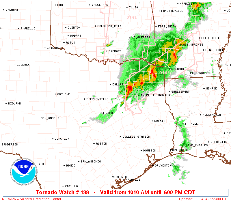
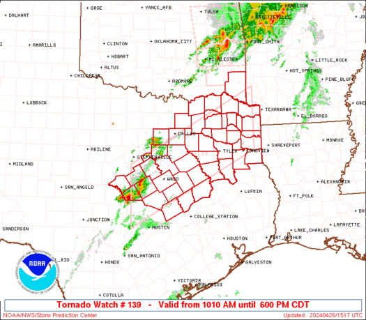
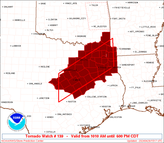
Tornado Watch Number 139
NWS Storm Prediction Center Norman OK
1010 AM CDT Fri Apr 26 2024
The NWS Storm Prediction Center has issued a
* Tornado Watch for portions of
Southeast Oklahoma
Central and Northeast Texas
* Effective this Friday morning and evening from 1010 AM until
600 PM CDT.
* Primary threats include...
A few tornadoes possible
Scattered large hail and isolated very large hail events to 2.5
inches in diameter possible
Scattered damaging wind gusts to 70 mph possible
SUMMARY...Thunderstorms are expected increase in coverage and
intensity through the late morning and afternoon, with a few severe
thunderstorms possible. Large hail, damaging winds, and a few
tornadoes may occur.
The tornado watch area is approximately along and 60 statute miles
north and south of a line from 50 miles west of Temple TX to 65
miles north northeast of Longview TX. For a complete depiction of
the watch see the associated watch outline update (WOUS64 KWNS
WOU9).
PRECAUTIONARY/PREPAREDNESS ACTIONS...
REMEMBER...A Tornado Watch means conditions are favorable for
tornadoes and severe thunderstorms in and close to the watch
area. Persons in these areas should be on the lookout for
threatening weather conditions and listen for later statements
and possible warnings.
&&
OTHER WATCH INFORMATION...CONTINUE...WW 138...
AVIATION...Tornadoes and a few severe thunderstorms with hail
surface and aloft to 2.5 inches. Extreme turbulence and surface wind
gusts to 60 knots. A few cumulonimbi with maximum tops to 500. Mean
storm motion vector 25030.
...Hart
   SEL9

   URGENT - IMMEDIATE BROADCAST REQUESTED
   Tornado Watch Number 139
   NWS Storm Prediction Center Norman OK
   1010 AM CDT Fri Apr 26 2024

   The NWS Storm Prediction Center has issued a

   * Tornado Watch for portions of
     Southeast Oklahoma
     Central and Northeast Texas

   * Effective this Friday morning and evening from 1010 AM until
     600 PM CDT.

   * Primary threats include...
     A few tornadoes possible
     Scattered large hail and isolated very large hail events to 2.5
       inches in diameter possible
     Scattered damaging wind gusts to 70 mph possible

   SUMMARY...Thunderstorms are expected increase in coverage and
   intensity through the late morning and afternoon, with a few severe
   thunderstorms possible.  Large hail, damaging winds, and a few
   tornadoes may occur.

   The tornado watch area is approximately along and 60 statute miles
   north and south of a line from 50 miles west of Temple TX to 65
   miles north northeast of Longview TX. For a complete depiction of
   the watch see the associated watch outline update (WOUS64 KWNS
   WOU9).

   PRECAUTIONARY/PREPAREDNESS ACTIONS...

   REMEMBER...A Tornado Watch means conditions are favorable for
   tornadoes and severe thunderstorms in and close to the watch
   area. Persons in these areas should be on the lookout for
   threatening weather conditions and listen for later statements
   and possible warnings.

   &&

   OTHER WATCH INFORMATION...CONTINUE...WW 138...

   AVIATION...Tornadoes and a few severe thunderstorms with hail
   surface and aloft to 2.5 inches. Extreme turbulence and surface wind
   gusts to 60 knots. A few cumulonimbi with maximum tops to 500. Mean
   storm motion vector 25030.

   ...Hart
 Note:
The Aviation Watch (SAW) product is an approximation to the watch area.
The actual watch is depicted by the shaded areas.
Note:
The Aviation Watch (SAW) product is an approximation to the watch area.
The actual watch is depicted by the shaded areas.
   SAW9
   WW 139 TORNADO OK TX 261510Z - 262300Z
   AXIS..60 STATUTE MILES NORTH AND SOUTH OF LINE..
   50W TPL/TEMPLE TX/ - 65NNE GGG/LONGVIEW TX/
   ..AVIATION COORDS.. 50NM N/S /60WSW ACT - 19SW TXK/
   HAIL SURFACE AND ALOFT..2.5 INCHES. WIND GUSTS..60 KNOTS.
   MAX TOPS TO 500. MEAN STORM MOTION VECTOR 25030.

   LAT...LON 32029827 34129429 32389429 30289827

   THIS IS AN APPROXIMATION TO THE WATCH AREA.  FOR A
   COMPLETE DEPICTION OF THE WATCH SEE WOUS64 KWNS
   FOR WOU9.
Watch 139 Status Report Messages:
STATUS REPORT #4 ON WW 139
VALID 262135Z - 262240Z
THE SEVERE WEATHER THREAT CONTINUES ACROSS THE ENTIRE WATCH AREA.
..WENDT..04/26/24
ATTN...WFO...SHV...FWD...
&&
STATUS REPORT FOR WT 139
SEVERE WEATHER THREAT CONTINUES FOR THE FOLLOWING AREAS
OKC089-262240-
OK
. OKLAHOMA COUNTIES INCLUDED ARE
MCCURTAIN
$$
TXC001-027-035-037-063-067-073-085-099-113-119-139-145-147-159-
161-183-193-203-213-217-223-231-251-257-277-281-289-293-309-315-
331-333-343-349-365-379-387-395-397-401-423-425-439-449-459-467-
499-262240-
TX
. TEXAS COUNTIES INCLUDED ARE
ANDERSON BELL BOSQUE
BOWIE CAMP CASS
CHEROKEE COLLIN CORYELL
DALLAS DELTA ELLIS
FALLS FANNIN FRANKLIN
FREESTONE GREGG HAMILTON
HARRISON HENDERSON HILL
HOPKINS HUNT JOHNSON
KAUFMAN LAMAR LAMPASAS
LEON LIMESTONE MCLENNAN
MARION MILAM MILLS
MORRIS NAVARRO PANOLA
RAINS RED RIVER ROBERTSON
ROCKWALL RUSK SMITH
SOMERVELL TARRANT TITUS
UPSHUR VAN ZANDT WOOD
$$
THE WATCH STATUS MESSAGE IS FOR GUIDANCE PURPOSES ONLY. PLEASE
REFER TO WATCH COUNTY NOTIFICATION STATEMENTS FOR OFFICIAL
INFORMATION ON COUNTIES...INDEPENDENT CITIES AND MARINE ZONES
CLEARED FROM SEVERE THUNDERSTORM AND TORNADO WATCHES.
$$
STATUS REPORT #3 ON WW 139
VALID 262045Z - 262140Z
THE SEVERE WEATHER THREAT CONTINUES ACROSS THE ENTIRE WATCH AREA.
..WENDT..04/26/24
ATTN...WFO...SHV...FWD...
&&
STATUS REPORT FOR WT 139
SEVERE WEATHER THREAT CONTINUES FOR THE FOLLOWING AREAS
OKC089-262140-
OK
. OKLAHOMA COUNTIES INCLUDED ARE
MCCURTAIN
$$
TXC001-027-035-037-063-067-073-085-099-113-119-139-145-147-159-
161-183-193-203-213-217-223-231-251-257-277-281-289-293-309-315-
331-333-343-349-365-379-387-395-397-401-423-425-439-449-459-467-
499-262140-
TX
. TEXAS COUNTIES INCLUDED ARE
ANDERSON BELL BOSQUE
BOWIE CAMP CASS
CHEROKEE COLLIN CORYELL
DALLAS DELTA ELLIS
FALLS FANNIN FRANKLIN
FREESTONE GREGG HAMILTON
HARRISON HENDERSON HILL
HOPKINS HUNT JOHNSON
KAUFMAN LAMAR LAMPASAS
LEON LIMESTONE MCLENNAN
MARION MILAM MILLS
MORRIS NAVARRO PANOLA
RAINS RED RIVER ROBERTSON
ROCKWALL RUSK SMITH
SOMERVELL TARRANT TITUS
UPSHUR VAN ZANDT WOOD
$$
THE WATCH STATUS MESSAGE IS FOR GUIDANCE PURPOSES ONLY. PLEASE
REFER TO WATCH COUNTY NOTIFICATION STATEMENTS FOR OFFICIAL
INFORMATION ON COUNTIES...INDEPENDENT CITIES AND MARINE ZONES
CLEARED FROM SEVERE THUNDERSTORM AND TORNADO WATCHES.
$$
STATUS REPORT #2 ON WW 139
VALID 261930Z - 262040Z
THE SEVERE WEATHER THREAT CONTINUES ACROSS THE ENTIRE WATCH AREA.
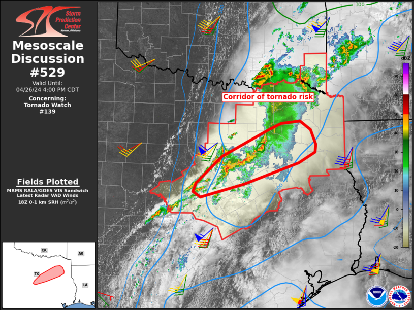
FOR ADDITIONAL INFORMATION SEE MESOSCALE DISCUSSION 529
..WENDT..04/26/24
ATTN...WFO...SHV...FWD...
&&
STATUS REPORT FOR WT 139
SEVERE WEATHER THREAT CONTINUES FOR THE FOLLOWING AREAS
OKC089-262040-
OK
. OKLAHOMA COUNTIES INCLUDED ARE
MCCURTAIN
$$
TXC001-027-035-037-063-067-073-085-099-113-119-139-145-147-159-
161-183-193-203-213-217-223-231-251-257-277-281-289-293-309-315-
331-333-343-349-365-379-387-395-397-401-423-425-439-449-459-467-
499-262040-
TX
. TEXAS COUNTIES INCLUDED ARE
ANDERSON BELL BOSQUE
BOWIE CAMP CASS
CHEROKEE COLLIN CORYELL
DALLAS DELTA ELLIS
FALLS FANNIN FRANKLIN
FREESTONE GREGG HAMILTON
HARRISON HENDERSON HILL
HOPKINS HUNT JOHNSON
KAUFMAN LAMAR LAMPASAS
LEON LIMESTONE MCLENNAN
MARION MILAM MILLS
MORRIS NAVARRO PANOLA
RAINS RED RIVER ROBERTSON
ROCKWALL RUSK SMITH
SOMERVELL TARRANT TITUS
UPSHUR VAN ZANDT WOOD
$$
THE WATCH STATUS MESSAGE IS FOR GUIDANCE PURPOSES ONLY. PLEASE
REFER TO WATCH COUNTY NOTIFICATION STATEMENTS FOR OFFICIAL
INFORMATION ON COUNTIES...INDEPENDENT CITIES AND MARINE ZONES
CLEARED FROM SEVERE THUNDERSTORM AND TORNADO WATCHES.
$$
STATUS REPORT #1 ON WW 139
VALID 261825Z - 261940Z
THE SEVERE WEATHER THREAT CONTINUES ACROSS THE ENTIRE WATCH AREA.
..WENDT..04/26/24
ATTN...WFO...SHV...FWD...
&&
STATUS REPORT FOR WT 139
SEVERE WEATHER THREAT CONTINUES FOR THE FOLLOWING AREAS
OKC089-261940-
OK
. OKLAHOMA COUNTIES INCLUDED ARE
MCCURTAIN
$$
TXC001-027-035-037-063-067-073-085-099-113-119-139-145-147-159-
161-183-193-203-213-217-223-231-251-257-277-281-289-293-309-315-
331-333-343-349-365-379-387-395-397-401-423-425-439-449-459-467-
499-261940-
TX
. TEXAS COUNTIES INCLUDED ARE
ANDERSON BELL BOSQUE
BOWIE CAMP CASS
CHEROKEE COLLIN CORYELL
DALLAS DELTA ELLIS
FALLS FANNIN FRANKLIN
FREESTONE GREGG HAMILTON
HARRISON HENDERSON HILL
HOPKINS HUNT JOHNSON
KAUFMAN LAMAR LAMPASAS
LEON LIMESTONE MCLENNAN
MARION MILAM MILLS
MORRIS NAVARRO PANOLA
RAINS RED RIVER ROBERTSON
ROCKWALL RUSK SMITH
SOMERVELL TARRANT TITUS
UPSHUR VAN ZANDT WOOD
$$
THE WATCH STATUS MESSAGE IS FOR GUIDANCE PURPOSES ONLY. PLEASE
REFER TO WATCH COUNTY NOTIFICATION STATEMENTS FOR OFFICIAL
INFORMATION ON COUNTIES...INDEPENDENT CITIES AND MARINE ZONES
CLEARED FROM SEVERE THUNDERSTORM AND TORNADO WATCHES.
$$
Note:
Click for Complete Product Text.
Tornadoes
Probability of 2 or more tornadoes
|
Mod (50%)
|
Probability of 1 or more strong (EF2-EF5) tornadoes
|
Low (20%)
|
Wind
Probability of 10 or more severe wind events
|
Mod (50%)
|
Probability of 1 or more wind events > 65 knots
|
Low (20%)
|
Hail
Probability of 10 or more severe hail events
|
Mod (50%)
|
Probability of 1 or more hailstones > 2 inches
|
Mod (40%)
|
Combined Severe Hail/Wind
Probability of 6 or more combined severe hail/wind events
|
High (80%)
|
For each watch, probabilities for particular events inside the watch
(listed above in each table) are determined by the issuing forecaster.
The "Low" category contains probability values ranging from less than 2%
to 20% (EF2-EF5 tornadoes), less than 5% to 20% (all other probabilities),
"Moderate" from 30% to 60%, and "High" from 70% to greater than 95%.
High values are bolded and lighter in color to provide awareness of
an increased threat for a particular event.


 @NWSSPC