 Note:
The expiration time in the watch graphic is amended if the watch is
replaced, cancelled or extended.
Note:
Note:
The expiration time in the watch graphic is amended if the watch is
replaced, cancelled or extended.
Note: Click for
Watch Status Reports.
SEL3
URGENT - IMMEDIATE BROADCAST REQUESTED
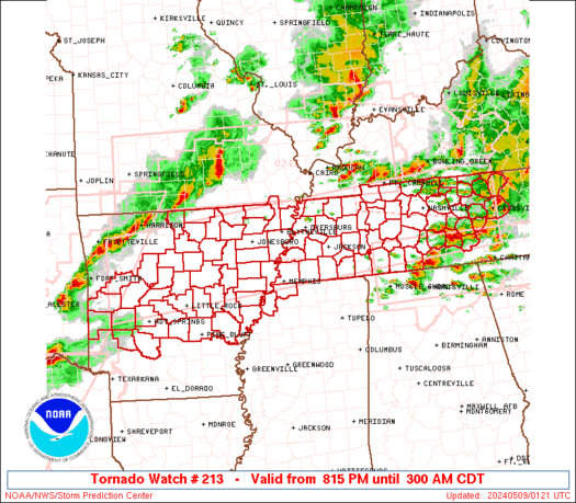
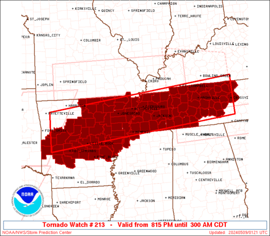
Tornado Watch Number 213
NWS Storm Prediction Center Norman OK
815 PM CDT Wed May 8 2024
The NWS Storm Prediction Center has issued a
* Tornado Watch for portions of
Central and Northern Arkansas
Missouri Bootheel
Northwest Mississippi
Western and Middle Tennessee
* Effective this Wednesday night and Thursday morning from 815 PM
until 300 AM CDT.
* Primary threats include...
A few tornadoes likely with a couple intense tornadoes possible
Widespread large hail and scattered very large hail events to 3
inches in diameter likely
Widespread damaging winds and isolated significant gusts to 80
mph likely
SUMMARY...Multiple rounds of severe thunderstorms will continue to
occur across the watch area into the overnight period. Supercells
and bowing storms capable of damaging winds, large hail, and
tornadoes will be possible.
The tornado watch area is approximately along and 55 statute miles
north and south of a line from 50 miles west of Russellville AR to
10 miles north northeast of Crossville TN. For a complete depiction
of the watch see the associated watch outline update (WOUS64 KWNS
WOU3).
PRECAUTIONARY/PREPAREDNESS ACTIONS...
REMEMBER...A Tornado Watch means conditions are favorable for
tornadoes and severe thunderstorms in and close to the watch
area. Persons in these areas should be on the lookout for
threatening weather conditions and listen for later statements
and possible warnings.
&&
OTHER WATCH INFORMATION...CONTINUE...WW 206...WW 208...WW
209...WW 210...WW 211...WW 212...
AVIATION...Tornadoes and a few severe thunderstorms with hail
surface and aloft to 3 inches. Extreme turbulence and surface wind
gusts to 70 knots. A few cumulonimbi with maximum tops to 500. Mean
storm motion vector 27035.
...Hart
   SEL3

   URGENT - IMMEDIATE BROADCAST REQUESTED
   Tornado Watch Number 213
   NWS Storm Prediction Center Norman OK
   815 PM CDT Wed May 8 2024

   The NWS Storm Prediction Center has issued a

   * Tornado Watch for portions of
     Central and Northern Arkansas
     Missouri Bootheel
     Northwest Mississippi
     Western and Middle Tennessee

   * Effective this Wednesday night and Thursday morning from 815 PM
     until 300 AM CDT.

   * Primary threats include...
     A few tornadoes likely with a couple intense tornadoes possible
     Widespread large hail and scattered very large hail events to 3
       inches in diameter likely
     Widespread damaging winds and isolated significant gusts to 80
       mph likely

   SUMMARY...Multiple rounds of severe thunderstorms will continue to
   occur across the watch area into the overnight period.  Supercells
   and bowing storms capable of damaging winds, large hail, and
   tornadoes will be possible.

   The tornado watch area is approximately along and 55 statute miles
   north and south of a line from 50 miles west of Russellville AR to
   10 miles north northeast of Crossville TN. For a complete depiction
   of the watch see the associated watch outline update (WOUS64 KWNS
   WOU3).

   PRECAUTIONARY/PREPAREDNESS ACTIONS...

   REMEMBER...A Tornado Watch means conditions are favorable for
   tornadoes and severe thunderstorms in and close to the watch
   area. Persons in these areas should be on the lookout for
   threatening weather conditions and listen for later statements
   and possible warnings.

   &&

   OTHER WATCH INFORMATION...CONTINUE...WW 206...WW 208...WW
   209...WW 210...WW 211...WW 212...

   AVIATION...Tornadoes and a few severe thunderstorms with hail
   surface and aloft to 3 inches. Extreme turbulence and surface wind
   gusts to 70 knots. A few cumulonimbi with maximum tops to 500. Mean
   storm motion vector 27035.

   ...Hart
 Note:
The Aviation Watch (SAW) product is an approximation to the watch area.
The actual watch is depicted by the shaded areas.
Note:
The Aviation Watch (SAW) product is an approximation to the watch area.
The actual watch is depicted by the shaded areas.
   SAW3
   WW 213 TORNADO AR MO MS TN 090115Z - 090800Z
   AXIS..55 STATUTE MILES NORTH AND SOUTH OF LINE..
   50W RUE/RUSSELLVILLE AR/ - 10NNE CSV/CROSSVILLE TN/
   ..AVIATION COORDS.. 50NM N/S /16ESE FSM - 56WNW VXV/
   HAIL SURFACE AND ALOFT..3 INCHES. WIND GUSTS..70 KNOTS.
   MAX TOPS TO 500. MEAN STORM MOTION VECTOR 27035.

   LAT...LON 36049398 36888501 35298501 34459398

   THIS IS AN APPROXIMATION TO THE WATCH AREA.  FOR A
   COMPLETE DEPICTION OF THE WATCH SEE WOUS64 KWNS
   FOR WOU3.
Watch 213 Status Report Messages:
STATUS REPORT #5 ON WW 213

VALID 090740Z - 090840Z

SEVERE WEATHER THREAT CONTINUES RIGHT OF A LINE FROM 15 SE LIT TO
30 NNW MEM TO 35 SSW CKV TO 25 WSW BWG.

..BROYLES..05/09/24

ATTN...WFO...LZK...MEG...OHX...

&&

STATUS REPORT FOR WT 213

SEVERE WEATHER THREAT CONTINUES FOR THE FOLLOWING AREAS

ARC001-019-035-053-059-069-077-095-107-123-090840-

AR
.    ARKANSAS COUNTIES INCLUDED ARE

ARKANSAS	     CLARK		 CRITTENDEN
GRANT		     HOT SPRING 	 JEFFERSON
LEE		     MONROE		 PHILLIPS
ST. FRANCIS
$$


MSC009-033-093-137-139-143-090840-

MS
.    MISSISSIPPI COUNTIES INCLUDED ARE

BENTON		     DESOTO		 MARSHALL
TATE		     TIPPAH		 TUNICA
$$


TNC003-015-021-023-027-031-033-035-037-039-041-043-047-049-055-
061-069-071-075-077-081-087-099-101-109-111-113-117-119-133-135-
137-141-147-149-157-159-165-167-169-175-177-181-185-187-189-
090840-

TN
.    TENNESSEE COUNTIES INCLUDED ARE

BEDFORD 	     CANNON		 CHEATHAM
CHESTER 	     CLAY		 COFFEE
CROCKETT	     CUMBERLAND 	 DAVIDSON
DECATUR 	     DE KALB		 DICKSON
FAYETTE 	     FENTRESS		 GILES
GRUNDY		     HARDEMAN		 HARDIN
HAYWOOD 	     HENDERSON		 HICKMAN
JACKSON 	     LAWRENCE		 LEWIS
MCNAIRY 	     MACON		 MADISON
MARSHALL	     MAURY		 OVERTON
PERRY		     PICKETT		 PUTNAM
ROBERTSON	     RUTHERFORD 	 SHELBY
SMITH		     SUMNER		 TIPTON
TROUSDALE	     VAN BUREN		 WARREN
WAYNE		     WHITE		 WILLIAMSON
WILSON
$$


THE WATCH STATUS MESSAGE IS FOR GUIDANCE PURPOSES ONLY.  PLEASE
REFER TO WATCH COUNTY NOTIFICATION STATEMENTS FOR OFFICIAL
INFORMATION ON COUNTIES...INDEPENDENT CITIES AND MARINE ZONES
CLEARED FROM SEVERE THUNDERSTORM AND TORNADO WATCHES.
$$

STATUS REPORT #4 ON WW 213

VALID 090635Z - 090740Z

SEVERE WEATHER THREAT CONTINUES RIGHT OF A LINE FROM 35 NNE DEQ
TO 35 SSW DYR TO 35 NNE MKL TO 20 WNW HOP.

..BROYLES..05/09/24

ATTN...WFO...LZK...MEG...OHX...

&&

STATUS REPORT FOR WT 213

SEVERE WEATHER THREAT CONTINUES FOR THE FOLLOWING AREAS

ARC001-019-035-037-051-053-059-069-077-085-095-097-107-109-117-
119-123-125-147-090740-

AR
.    ARKANSAS COUNTIES INCLUDED ARE

ARKANSAS	     CLARK		 CRITTENDEN
CROSS		     GARLAND		 GRANT
HOT SPRING	     JEFFERSON		 LEE
LONOKE		     MONROE		 MONTGOMERY
PHILLIPS	     PIKE		 PRAIRIE
PULASKI 	     ST. FRANCIS	 SALINE
WOODRUFF
$$


MSC009-033-093-137-139-143-090740-

MS
.    MISSISSIPPI COUNTIES INCLUDED ARE

BENTON		     DESOTO		 MARSHALL
TATE		     TIPPAH		 TUNICA
$$


TNC003-005-015-017-021-023-027-031-033-035-037-039-041-043-047-
049-055-061-069-071-075-077-079-081-083-085-087-099-101-109-111-
113-117-119-125-133-135-137-141-147-149-157-159-161-165-167-169-
175-177-181-185-187-189-090740-

TN
.    TENNESSEE COUNTIES INCLUDED ARE

BEDFORD 	     BENTON		 CANNON
CARROLL 	     CHEATHAM		 CHESTER
CLAY		     COFFEE		 CROCKETT
CUMBERLAND	     DAVIDSON		 DECATUR
DE KALB 	     DICKSON		 FAYETTE
FENTRESS	     GILES		 GRUNDY
HARDEMAN	     HARDIN		 HAYWOOD
HENDERSON	     HENRY		 HICKMAN
HOUSTON 	     HUMPHREYS		 JACKSON
LAWRENCE	     LEWIS		 MCNAIRY
MACON		     MADISON		 MARSHALL
MAURY		     MONTGOMERY 	 OVERTON
PERRY		     PICKETT		 PUTNAM
ROBERTSON	     RUTHERFORD 	 SHELBY
SMITH		     STEWART		 SUMNER
TIPTON		     TROUSDALE		 VAN BUREN
WARREN		     WAYNE		 WHITE
WILLIAMSON	     WILSON
$$


THE WATCH STATUS MESSAGE IS FOR GUIDANCE PURPOSES ONLY.  PLEASE
REFER TO WATCH COUNTY NOTIFICATION STATEMENTS FOR OFFICIAL
INFORMATION ON COUNTIES...INDEPENDENT CITIES AND MARINE ZONES
CLEARED FROM SEVERE THUNDERSTORM AND TORNADO WATCHES.
$$

STATUS REPORT #3 ON WW 213

VALID 090540Z - 090640Z

THE SEVERE WEATHER THREAT CONTINUES ACROSS THE ENTIRE WATCH AREA.

..BROYLES..05/09/24

ATTN...WFO...LZK...MEG...OHX...

&&

STATUS REPORT FOR WT 213

SEVERE WEATHER THREAT CONTINUES FOR THE FOLLOWING AREAS

ARC001-019-021-023-029-031-035-037-045-051-053-055-059-063-067-
069-075-077-083-085-093-095-097-105-107-109-111-113-115-117-119-
123-125-127-141-145-147-149-090640-

AR
.    ARKANSAS COUNTIES INCLUDED ARE

ARKANSAS	     CLARK		 CLAY
CLEBURNE	     CONWAY		 CRAIGHEAD
CRITTENDEN	     CROSS		 FAULKNER
GARLAND 	     GRANT		 GREENE
HOT SPRING	     INDEPENDENCE	 JACKSON
JEFFERSON	     LAWRENCE		 LEE
LOGAN		     LONOKE		 MISSISSIPPI
MONROE		     MONTGOMERY 	 PERRY
PHILLIPS	     PIKE		 POINSETT
POLK		     POPE		 PRAIRIE
PULASKI 	     ST. FRANCIS	 SALINE
SCOTT		     VAN BUREN		 WHITE
WOODRUFF	     YELL
$$


MSC033-143-090640-

MS
.    MISSISSIPPI COUNTIES INCLUDED ARE

DESOTO		     TUNICA
$$


MOC069-155-090640-

MO
.    MISSOURI COUNTIES INCLUDED ARE

DUNKLIN 	     PEMISCOT
$$


TNC003-005-015-017-021-023-027-031-033-035-037-039-041-043-045-
047-049-053-055-061-069-071-075-077-079-081-083-085-087-095-097-
099-101-109-111-113-117-119-125-131-133-135-137-141-147-149-157-
159-161-165-167-169-175-177-181-183-185-187-189-090640-

TN
.    TENNESSEE COUNTIES INCLUDED ARE

BEDFORD 	     BENTON		 CANNON
CARROLL 	     CHEATHAM		 CHESTER
CLAY		     COFFEE		 CROCKETT
CUMBERLAND	     DAVIDSON		 DECATUR
DE KALB 	     DICKSON		 DYER
FAYETTE 	     FENTRESS		 GIBSON
GILES		     GRUNDY		 HARDEMAN
HARDIN		     HAYWOOD		 HENDERSON
HENRY		     HICKMAN		 HOUSTON
HUMPHREYS	     JACKSON		 LAKE
LAUDERDALE	     LAWRENCE		 LEWIS
MCNAIRY 	     MACON		 MADISON
MARSHALL	     MAURY		 MONTGOMERY
OBION		     OVERTON		 PERRY
PICKETT 	     PUTNAM		 ROBERTSON
RUTHERFORD	     SHELBY		 SMITH
STEWART 	     SUMNER		 TIPTON
TROUSDALE	     VAN BUREN		 WARREN
WAYNE		     WEAKLEY		 WHITE
WILLIAMSON	     WILSON
$$


THE WATCH STATUS MESSAGE IS FOR GUIDANCE PURPOSES ONLY.  PLEASE
REFER TO WATCH COUNTY NOTIFICATION STATEMENTS FOR OFFICIAL
INFORMATION ON COUNTIES...INDEPENDENT CITIES AND MARINE ZONES
CLEARED FROM SEVERE THUNDERSTORM AND TORNADO WATCHES.
$$

STATUS REPORT #2 ON WW 213

VALID 090440Z - 090540Z

SEVERE WEATHER THREAT CONTINUES RIGHT OF A LINE FROM 35 NE DEQ TO
35 SE FSM TO 30 W BVX TO 20 SE POF.

..GOSS..05/09/24

ATTN...WFO...LZK...MEG...OHX...

&&

STATUS REPORT FOR WT 213

SEVERE WEATHER THREAT CONTINUES FOR THE FOLLOWING AREAS

ARC001-019-021-023-029-031-035-037-045-051-053-055-059-063-067-
069-075-077-083-085-093-095-097-105-107-109-111-113-115-117-119-
123-125-127-141-145-147-149-090540-

AR
.    ARKANSAS COUNTIES INCLUDED ARE

ARKANSAS	     CLARK		 CLAY
CLEBURNE	     CONWAY		 CRAIGHEAD
CRITTENDEN	     CROSS		 FAULKNER
GARLAND 	     GRANT		 GREENE
HOT SPRING	     INDEPENDENCE	 JACKSON
JEFFERSON	     LAWRENCE		 LEE
LOGAN		     LONOKE		 MISSISSIPPI
MONROE		     MONTGOMERY 	 PERRY
PHILLIPS	     PIKE		 POINSETT
POLK		     POPE		 PRAIRIE
PULASKI 	     ST. FRANCIS	 SALINE
SCOTT		     VAN BUREN		 WHITE
WOODRUFF	     YELL
$$


MSC033-143-090540-

MS
.    MISSISSIPPI COUNTIES INCLUDED ARE

DESOTO		     TUNICA
$$


MOC069-155-090540-

MO
.    MISSOURI COUNTIES INCLUDED ARE

DUNKLIN 	     PEMISCOT
$$


TNC003-005-015-017-021-023-027-031-033-035-037-039-041-043-045-
047-049-053-055-061-069-071-075-077-079-081-083-085-087-095-097-
099-101-109-111-113-117-119-125-131-133-135-137-141-147-149-157-
159-161-165-167-169-175-177-181-183-185-187-189-090540-

TN
.    TENNESSEE COUNTIES INCLUDED ARE

BEDFORD 	     BENTON		 CANNON
CARROLL 	     CHEATHAM		 CHESTER
CLAY		     COFFEE		 CROCKETT
CUMBERLAND	     DAVIDSON		 DECATUR
DE KALB 	     DICKSON		 DYER
FAYETTE 	     FENTRESS		 GIBSON
GILES		     GRUNDY		 HARDEMAN
HARDIN		     HAYWOOD		 HENDERSON
HENRY		     HICKMAN		 HOUSTON
HUMPHREYS	     JACKSON		 LAKE
LAUDERDALE	     LAWRENCE		 LEWIS
MCNAIRY 	     MACON		 MADISON
MARSHALL	     MAURY		 MONTGOMERY
OBION		     OVERTON		 PERRY
PICKETT 	     PUTNAM		 ROBERTSON
RUTHERFORD	     SHELBY		 SMITH
STEWART 	     SUMNER		 TIPTON
TROUSDALE	     VAN BUREN		 WARREN
WAYNE		     WEAKLEY		 WHITE
WILLIAMSON	     WILSON
$$


THE WATCH STATUS MESSAGE IS FOR GUIDANCE PURPOSES ONLY.  PLEASE
REFER TO WATCH COUNTY NOTIFICATION STATEMENTS FOR OFFICIAL
INFORMATION ON COUNTIES...INDEPENDENT CITIES AND MARINE ZONES
CLEARED FROM SEVERE THUNDERSTORM AND TORNADO WATCHES.
$$

STATUS REPORT #1 ON WW 213

VALID 090140Z - 090240Z

THE SEVERE WEATHER THREAT CONTINUES ACROSS THE ENTIRE WATCH AREA.

..BENTLEY..05/09/24

ATTN...WFO...LZK...MEG...OHX...

&&

STATUS REPORT FOR WT 213

SEVERE WEATHER THREAT CONTINUES FOR THE FOLLOWING AREAS

ARC001-005-019-021-023-029-031-035-037-045-049-051-053-055-059-
063-065-067-069-075-077-083-085-093-095-097-105-107-109-111-113-
115-117-119-121-123-125-127-135-137-141-145-147-149-090240-

AR
.    ARKANSAS COUNTIES INCLUDED ARE

ARKANSAS	     BAXTER		 CLARK
CLAY		     CLEBURNE		 CONWAY
CRAIGHEAD	     CRITTENDEN 	 CROSS
FAULKNER	     FULTON		 GARLAND
GRANT		     GREENE		 HOT SPRING
INDEPENDENCE	     IZARD		 JACKSON
JEFFERSON	     LAWRENCE		 LEE
LOGAN		     LONOKE		 MISSISSIPPI
MONROE		     MONTGOMERY 	 PERRY
PHILLIPS	     PIKE		 POINSETT
POLK		     POPE		 PRAIRIE
PULASKI 	     RANDOLPH		 ST. FRANCIS
SALINE		     SCOTT		 SHARP
STONE		     VAN BUREN		 WHITE
WOODRUFF	     YELL
$$


MSC033-143-090240-

MS
.    MISSISSIPPI COUNTIES INCLUDED ARE

DESOTO		     TUNICA
$$


MOC069-155-090240-

MO
.    MISSOURI COUNTIES INCLUDED ARE

DUNKLIN 	     PEMISCOT
$$


TNC003-005-015-017-021-023-027-031-033-035-037-039-041-043-045-
047-049-053-055-061-069-071-075-077-079-081-083-085-087-095-097-
099-101-109-111-113-117-119-125-131-133-135-137-141-147-149-157-
159-161-165-167-169-175-177-181-183-185-187-189-090240-

TN
.    TENNESSEE COUNTIES INCLUDED ARE

BEDFORD 	     BENTON		 CANNON
CARROLL 	     CHEATHAM		 CHESTER
CLAY		     COFFEE		 CROCKETT
CUMBERLAND	     DAVIDSON		 DECATUR
DE KALB 	     DICKSON		 DYER
FAYETTE 	     FENTRESS		 GIBSON
GILES		     GRUNDY		 HARDEMAN
HARDIN		     HAYWOOD		 HENDERSON
HENRY		     HICKMAN		 HOUSTON
HUMPHREYS	     JACKSON		 LAKE
LAUDERDALE	     LAWRENCE		 LEWIS
MCNAIRY 	     MACON		 MADISON
MARSHALL	     MAURY		 MONTGOMERY
OBION		     OVERTON		 PERRY
PICKETT 	     PUTNAM		 ROBERTSON
RUTHERFORD	     SHELBY		 SMITH
STEWART 	     SUMNER		 TIPTON
TROUSDALE	     VAN BUREN		 WARREN
WAYNE		     WEAKLEY		 WHITE
WILLIAMSON	     WILSON
$$


THE WATCH STATUS MESSAGE IS FOR GUIDANCE PURPOSES ONLY.  PLEASE
REFER TO WATCH COUNTY NOTIFICATION STATEMENTS FOR OFFICIAL
INFORMATION ON COUNTIES...INDEPENDENT CITIES AND MARINE ZONES
CLEARED FROM SEVERE THUNDERSTORM AND TORNADO WATCHES.
$$
Note:
Click for Complete Product Text.
Tornadoes
Probability of 2 or more tornadoes
|
Mod (60%)
|
Probability of 1 or more strong (EF2-EF5) tornadoes
|
Mod (40%)
|
Wind
Probability of 10 or more severe wind events
|
High (90%)
|
Probability of 1 or more wind events > 65 knots
|
High (70%)
|
Hail
Probability of 10 or more severe hail events
|
High (90%)
|
Probability of 1 or more hailstones > 2 inches
|
High (80%)
|
Combined Severe Hail/Wind
Probability of 6 or more combined severe hail/wind events
|
High (>95%)
|
For each watch, probabilities for particular events inside the watch
(listed above in each table) are determined by the issuing forecaster.
The "Low" category contains probability values ranging from less than 2%
to 20% (EF2-EF5 tornadoes), less than 5% to 20% (all other probabilities),
"Moderate" from 30% to 60%, and "High" from 70% to greater than 95%.
High values are bolded and lighter in color to provide awareness of
an increased threat for a particular event.


 @NWSSPC


